
A lemon or a tangerine?
What is this all about
Almost 300 years ago, science history was made in the Torne Valley. A group of French natural scientists arrived in the North to measure the shape of the Earth. At the same time, they recorded descriptions of local life in their journals.

Travelogues take you back in time
The expedition notes resulted in the books The Figure of the Earth (La Figure de la Terre, 1738) and Journal of a voyage to the North (Journal d'un voyage au Nord, 1744).
The former was written by the leader of the expedition, the academic Pierre Louis Moreau de Maupertuis. The work is a mixture of a scientific report and a travelogue. The latter was a journal written and illustrated by a member of the expedition and clergyman, Abbé Réginald Outhier.
Thanks to these works, we can even today follow in the footsteps of the French explorers to the Torne Valley of the 1730s.
Is the Earth shaped like a tangerine or a lemon?
In the early 1700s, there were competing theories about the shape of the Earth, and citrus fruits were used to illustrate the different views.

Simply put, it was a dispute between Cartesian and Newtonian natural science. According to the French philosopher and mathematician René Descartes (1596–1650), the Earth tapered at its poles like a lemon.
According to the English physicist and mathematician Isaac Newton's (1643–1727) theory of gravitation, the Earth is flattened at its poles like a tangerine.
France wanted success in science and shipping
To resolve the dispute, the French Académie des sciences sent an expedition to the South American equator in 1735, and a year later another expedition to the Torne Valley by the Arctic Circle.

The expeditions would measure the length of one degree of the meridian arc. If it were longer at the Arctic Circle than in France and at the equator, the Earth would be flattened at the poles.
For France, measuring the shape of the Earth was both a matter of prestige and a practical matter. Colonial and commercial shipping benefited from more accurate nautical charts. King Louis XV of France was ready to invest in degree measuring.

Research in the Arctic Circle
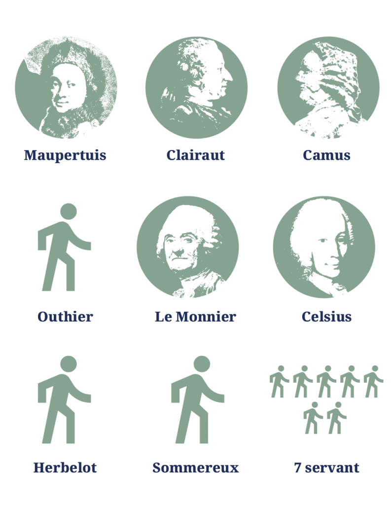
The eight-member northern expedition was led by mathematician and astronomer Pierre Louis Moreau de Maupertuis (1698–1759).
The expedition spent a year in the hills between Tornio and Pello, taking geodetic measurements with the best research equipment of the time.

In the summer and autumn of 1736, the expedition built markers (signals) and a chain of survey triangulations on the hills with the help of local people. A lot of trees were cut down on the hills, as a line of sight from one marker to the other had to be established.
The researchers split into groups and travelled back and forth between the measurement points. A large number of local helpers were always involved in the research. Step after step, countless nights slept out and mosquitoes slapped were accumulated.
Triangulation based on trigonometry
Triangulation had become an established method of cartography in the 1500s and 1600s. Once the length of one side of one triangle in a chain of triangles (the baseline) is known, the rest can be calculated trigonometrically by measuring the angles between the sides.
A quadrant was used to measure the angles.

The Maupertuis expedition measured the baseline of the chain on the ice of the Torne at Ylitornio. The work was carried out in December in severe frost.
For the measurement, wooden sticks about 10 metres long were placed on the ice, one after the other, for a distance of about 14 kilometres.
Distance measured by the stars
Once the chain of survey triangulations had been built in the summer and the distance between Tornio and Pello had been measured, it was time to move on to the night sky.
In the autumn of 1736, observatories were built in Tornio and Pello. In these, scientists measured the position of points on the meridian arc in the zenith sector. The fixed star used was the δ or delta star of the constellation of the Dragon. This was used to calculate the difference in degrees between the ends of the triangle.

Once the length of the degree was measured, it could be compared with a similar measurement made previously in France.
The process may sound simple, but in the circumstances of that particular period it was not. Just the task of transporting large and valuable instruments to the measurement points was an operation in itself. Fortunately for the expedition, the Torne proved to be a good passage.

A major scientific achievement
The Torne Valley was set as an important stage for the history of science when the expedition became the first in the world to empirically prove that the Earth was flattened at the poles. The measurement confirmed Newton's theory of gravitation.

The next major triangulation project in Finland was the measurements for the Struve Geodetic Arc in 1830–1855. In the chain of survey triangulations from the Arctic Ocean to the Black Sea, the same points were used for the Torne Valley as in the measurements conducted by Maupertuis 100 years earlier.
Triangulation was the preferred method of measurement until the late 1980s. At that time it was replaced by GPS satellite positioning. The National Land Survey of Finland was one of the first in the world to implement it in 1986.


The Figure of the Earth
Pierre Louis Moreau de Maupertuis's scientific report and travelogue La Figure de la Terre was first published in France in 1738. The next contemporary editions were printed in the same and the following year.
The full name of the work is called La figure de la terre déterminee par les observations de MM. Maupertuis, Clairaut, Camus, Le Monnier, Outhier, Celsius au cercle polaire.
The work was translated into Swedish and English (The Figure of the Earth) the same year, and a few years later into German and Latin. The Swedish translation, called Jordens Figur, was done by the expedition's translator, the young Anders Hellant from Tornio.
In Finland, the book was first published as a full translation in 2019 under the title Maan muoto.
Previously, it had been partially translated as Maapallon muoto in the 1977 Torne Valley yearbook, Tornionlaakson vuosikirja.
A digitised version of the original work can be found here.
A digitised version of the English translation can be found here.
Journal of a Voyage to the North
Réginald Outhier's Journal d'un voyage au Nord en 1736 & 1737 was published in 1744.
It was translated into German in 1759 and into English (Journal of a voyage to the North) in 1808. English translation is a part of a large collection of travel books edited by John Pinkerton.
The first Finnish translation, Matka Pohjan perille, was published in 1975. The second revised and supplemented edition was published in 2011.
Outhier's work was translated into Swedish in 1982 as Journal från en resa i Norden år 1736–1737.
A digitised version of the original work can be found here.
A digitised version of the English translation can be found here. Outhiers journal is part of the volume 1.
Maupertuis stories from The Figure of the Earth are published in the same volume in Pinkertons collection A general collection of the best and most interesting voyages and travels in all parts of the world; many of which are now first translated into English (1808).
